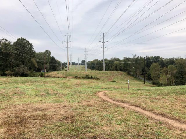
After years of dedicated planning and construction, Montgomery Parks opened the Powerline Trail, also known as the Pepco Trail, in October 2018.
The 6.8-mile trail, which kicks off from South Germantown Recreational Park in Germantown, Md. and terminates at North Potomac’s Muddy Branch Stream Park, marked the first use of power corridors for recreational use in Montgomery County. In my final days before shipping out for my freshman year of college, I decided to hit the trail to see if it would live up to the hype.
The origins of the trail date back to 2015, when power companies Pepco and Exelon were nearing a merger. Dave Magill, the Maryland advocacy director for MORE (Mid-Atlantic Off-Road Enthusiasts), remembers first hearing of the possibility of including the construction of a trail as a condition in the merger.
“A bike advocate, whose name I cannot remember, was chatting with me and said, “you know, Pepco hasn’t been very good with allowing trails of any kind, whether bike or hikers, either on or even across their power lines. Maybe to get an approval, they’ll have to go before the public utility commission (PUC). This is an opportunity to intervene in the merger and ask for them to change their policy about trails. That idea really resonated with me.”
Truth be told, my run at the Powerline Trail was not set up for success. The convenient time I picked to run was just before noon on a hot September morning, not ideal for a trail with lengthy exposed sections (or most runs at all, for that matter). I also had difficulties finding the start, as the trail didn’t have significant advertisement in the spacious South Germantown Regional Park or have its own parking lot (though it is worth noting that Montgomery Parks wants to build a lot on the property) and wasn’t on the map I picked up at the Germantown Soccerplex. At last, I resolved to follow the power lines and I latched onto a mowed path just beyond the facility’s soccer fields.
MORE pitched Montgomery Parks on the idea of the trail, though they weren’t certain that the department would share their enthusiasm. “[MORE] brought us in probably after the first six, eight months of doing their work trying to get our support,” Bob Turnbull, the Natural Surface Trail Construction Manager for Montgomery Parks, said. “We jumped on it. We’ve always tried to work with Pepco, it’s been difficult before this. Their job is to provide electricity. Their job is not to provide public access.”
Though Pepco was opposed to the trails at the onset, they ultimately consented and became valuable partners, not only allowing the land to be used but also spending money for the trail’s design.
“Pepco needed approvals from Montgomery County to get the merger done and ultimately decided to settle with us on our ask,” Magill said. “The result was a pilot project, which is the Pepco trail. Pepco totally honored their agreement, that they would spend the money to design these trails, to make the land available and pay for the design.”
The opening to my Powerline trail experience was a rough one, but once I found the 0.0 mile marker signifying the start of the trail about a quarter-mile into my run and followed it for a few minutes, I was blown away. The vistas across the meadows were spectacular, with the imposing towers above and open spaces all around. The corridor was a part of Maryland that I had never really seen before (let alone explored), but one that felt interesting and invigorating.
Views aside, the experience of running on the trail felt unique as well. The natural surface trail, built by the Montgomery Parks staff, was a welcome reprieve from the concrete sidewalks that frequented my summer runs, and the continually winding trail provided a variety of inclines, declines and turns. According to Turnbull, the trail was built to natural surface sustainability standard and not accessibility standard due to its relatively narrow width and loose rock surface, and a couple nearly twisted ankles gave me scares through the opening mile of the run. But overall, between the scenery, surface and quick elevation changes, it felt like a location straight from a cross country coach’s dream.
Development for the trail started a couple months after the merger. Though three trails, one paved, one unpaved, and one combination, were originally discussed, the expensive price tag of constructing a paved trail persuaded Montgomery Parks to pursue the combination option, which was considered a natural surface trail. The department aimed to make the trail accessible for all types of users, rather than make a separate trail for each group of users. “We wanted to design a natural surface trail that was multi-use,” Turnbull said. “You could have hikers, equestrians, and mountain bikers, and runners, bird watchers, dog walkers, the majority of users. We wanted to be open for everybody.”
Safety was also a major factor in the design and construction, given the trail’s proximity to power lines. “We needed to make sure there was vertical clearance, especially for equestrians,” Turnbull said. “And we wanted to make sure that we weren’t so close to a power pole that if it was struck by lightning while the user was right there, it couldn’t transfer the energy to the user. We also wanted to set back off the properties, because we didn’t want to impact all the neighbors along the corridor, to minimize our impact.”
The expansive corridor was certainly unfamiliar territory for me, but several of the trail’s useful amenities went a long way in helping me feel safe and on the right path. Mile marker posts were placed every 0.2 miles with the intention of helping with the location of users in cases of emergency, but they were also beneficial to me in monitoring my run. I also appreciated the most expensive aspect of the trail, the road crossings. Those features required additional partnerships, bringing in transportation officials from the county and state levels.
“The road crossings, we worked diligently with Montgomery County Department of Transportation and the state highway to design those and make those as safe as possible,” Turnbull said. “Some of them are simply just signage and striping on the road. Some of them are a lot more involved. Four out of the 10 crossing were quite expensive. It was quite the capital investment for us, but it was necessary. You’re introducing trail users to somewhere they’ve never been and people on the road who never had a trail cross there before. We want to be bold, we want to make a statement, we want to make sure everyone is safe. We really took vision zero seriously in this endeavor.”
Around mile three, the path diverged and I veered left along the equestrian/biker portion of the trail. The trail, which connects the multi-use path back to the hiker-only portion of the Powerline Trail, directed me into the scenery and greatly appreciated shade of Seneca Creek Park. The park portion was made possible by yet another collaboration.
“Because of that connector trail on state park that uses part of the Seneca Creek Greenway to get to Riffleford Road and use the Seneca Ridge trail to get back to the Pepco rightaway, that’s an additional two miles that’s on state ground,” Turnbull said. “We worked with the state and MORE worked with the state to make that connection multi-use.”
By the time I turned around and headed back toward Germantown, I was soaked in sweat and realized that perhaps I had bitten off more than I could chew on the deceptively difficult trail. Even with the sun beating down and leg fatigue mounting, navigating the trail was entertaining. On one creek crossing, I had to channel my inner long jumper and bound across, while some of the longer inclines gave me flashbacks to my high school glory days. All the while, I soaked up the sights of the power lines and the rolling Maryland hills.
The opening of the trail was delayed multiple months by the construction of the road crossings, but in October 2018, the Powerline Trail was ready for public use. Montgomery Parks quickly resolved a couple issues with local property owners when trails came too close, while MORE took responsibility for maintenance of the trail, including the frequent mowing that the natural surface trail required.
Montgomery Parks hopes to expand the trail to Bethesda in the coming years, which would extend the length to around 13 miles. But even at its current length, the trail is a convenient and enjoyable option for users. A major benefit is the opportunities that the trail provides to connect to other local trails, such as Hoyles Mill to the north or Muddy Branch trail to the south. Those connections, plus the unique views that each trail provides, makes the trail a major draw for all types of users.
“Montgomery County has done a great job with stream valleys, but they don’t always connect,” Magill said. “The Pepco trail offers a great opportunity to connect. I think it provides an open air trail, which you don’t get very much. While some people may say, “I’m not sure that I like the views with the power lines in them,” the fact is you get to see several miles across our landscape and that’s of real interest. I was just really struck by the level of birdlife on sections of the trail. [The trail] exposes a little different side of the local nature as well as that open air experience and the connections that it represents.”
The completion of the trail itself is an accomplishment itself, one made possible by partnerships across an array of diverse groups.
“I can’t say this enough with Pepco, they’ve been really responsive, really good to work with from the top down,” Turnbull said. “They had the CEO of Exelon out there for the grand opening. All the players have been great: MORE, mountain bikers, all the horseback people, Department of Transportation, state highway. It’s definitely not a one person or one entity show, it’s been a major partnership, a bunch of different energies coming together to get this done.”
I finished my run just outside of South Germantown Regional Park after six breathtaking, hilly, and memorable miles. My distance running training has taken me to places across the county and even the East Coast, but nothing quite like the Powerline Trail. The trail is in stark contrast from my other go-to options, the paved Rock Creek Trail on the eastern side of Montgomery County and the C&O Canal Towpath on Maryland’s western border, and fills a cool niche. Obviously, the geography, scenery, and surface of the corridor is unique, but for me it cultivated a sense of adventure and power that is rare to distance running. And its history adds yet another “wow” factor, showing that even as it becomes more and more difficult to build trails, there’s always room for creative thinking, connection, and collaboration to make something great.
The Powerline Trail is neither perfect nor suited to be a constant staple for training, but with a little more hill training and a lot more favorable of a weather forecast, I’d love to come back again.
Recent Stories
Looking for our race calendar? Click here Submit races here or shop local for running gear
Carderock Half Marathon
May 18th, 2025
7:30 AM Start
Race on the scenic C&O Towpath
$65.00 through 2/28
$75.00 – 2/28 through 4/30
$85.00 – 4/30 through 5/18 at 7:29 AM
Race Course and Finish Line will be open for 3 1/2 hours.
Revenge of the Penguins 10/20 Miler
Start/Finish
– C&O Canal Towpath, Carderock Recreation Area,
Clara Barton Parkway, Potomac, MD
Course
– On the historic C&O Canal Towpath
between Mile post 2.0 & Mile post 12.0.
– Flat, shady, tree-lined, with scenic riverside vistas
the course you


